How healthy are Canada’s waters?

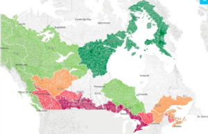
Alt Text: A map of Canada displaying regions in different colors. The northwest region is in dark green, central Canada is in light green, the southwest region is in pink, and the southeast region is in orange. Major cities and regional abbreviations are labeled, including Y.T., N.W.T., B.C., ALTA., SASK., MAN., ONT., and QUE.

Canadian French Translation: Carte du Canada montrant des régions de différentes couleurs : nord-ouest en vert foncé, centre en vert clair, sud-ouest en rose et sud-est en orange. Les grandes villes et les abréviations des régions telles que Y.T./N.W.T./C.-B./ALB./SASK./MAN./ONT./et QUE. sont indiquées.

(Note: The translation includes both the English labels as they appear on the map and their French counterparts to align with typical Canadian bilingual labeling conventions.).

On June 13th we hosted WWF-Canada as they launched the first comprehensive report on the health of Canada’s freshwater ecosystems. 5-years in the making, this assessment reviews Canada’s 25 major watersheds and 167 sub-watersheds for detailed data that together paints an important picture on the health of waters. 

The full webinar can now be viewed here.

Please check out the Watershed Reports website, where you can dig deeper on your local watershed, at watershedreports.wwf.ca

This is quite an accomplishment and we’d like to extend our thanks to WWF-Canada for leading this important work!

Scroll to Top